|
I didn't sleep all that well. Maybe the metal bed was too hard. I
got up at 7:30 AM to what looked like another perfect day. The hut
was on a clear grassy crest on top of Mount Wills (1757m) and had
great views to the east. I didn't leave till around 9 AM and after a
little bit of initial trouble finding the trail to Mt Wills South
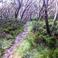
(1621m), I picked it up. It went through grassy wooded snowgum
forest and although faint, was followable. The views east and west
were great and I really enjoyed the walking. There were also boulder
outcrops adding to the beautiful scenery. No views from Mt Wills
South, which was the last peak of the Bogong High Plains.
From here I followed overgrown foot tracks and fire trails
through increasingly dense forest. Also some blackberries. On the
way down I met a hiker on the way up who had just started a week's
hike south along the AAWT. We had a brief chat and continued on our
separate ways. I reached the Omeo Road about 11:30 AM and had my
first break. The next sections involved quite a lot of scrub-bashing
along older overgrown fire trails though not as bad as a few days
ago and not wet. On the other hand I picked up lots of spider-webs
and bugs. It wasn't very pleasant hiking but I could follow the
trail and make reasonable time.
The route went downhill to Gill Creek which was ankle deep and,
after working out the shallowest route, I dashed across. On the
other side was more very old overgrown fire trail which climbed
steeply uphill for a few kilometres until it reached a ridge where I
stopped and had late lunch. Another tedious section. Here I joined a
better forest road for another long descent into the valley of the
Mitta Mitta River in a semi-rural valley.
I reached Taylors Crossing, a pedestrian suspension bridge across
the Mitta Mitta, where there was a designated hikers campsite. It
was 6:30 PM and I had time for a quick nude dip in the river before
cooking dinner. I'm a little ahead of schedule and have a relatively
easy day tomorrow to my next food dump. Went to bed at 9 PM.
Star-filled night but already a heavy dew.
|