|
There was again a heavy frost, but it wasn't as cold in the hut
as it was in the tent the previous night. I packed and left by
7:45am, and set out eastwards into the rising sun. In fact, all day
the route seemed to adjust itself so that I always seemed to be
walking into the sun.
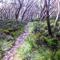
The walking was easy, along disused but clear 4WD tracks, and it
was easy to maintain a good pace. The trail generally crossed grassy
alpine meadows, occasionally crossing small streams, and every so
often climbing over a low spur or saddle. The crowns of most
surrounding hills were lightly timbered with snow gums. There were
not as many abrupt peaks within view, although Mt Jagungal was often
visible behind, and Tabletop Mt (1784m) loomed ahead. Most of my
walking was around 1500-1600m.
The countryside began to show signs of its history when sheep and
maybe cattle were brought here in the summers to graze. Occasional
bits of fences and gates. Towards lunchtime the trail began to climb
onto the crest of The Great Divide again as I approached Tabletop Mt
and I could see vast distances to the east to the Monaro Tableland
and glimpses of Lake Eucumbene.
The trail passed over the shoulder of Tabletop Mt during the
afternoon and then descended through an old mining area though there
were few obvious traces. Around 4:30pm I reached a junction where I
left the AAWT to walk a kilometer through snowgum forest to Four
Mile Hut which is an original miners hut, clad with flattened (and
cleaned!) fuel cans, with lots of historic junk around and set in
its own little alpine valley. Magic! I was early enough to
have a wash and wash out a few clothes and had double dinner again
because I get to my next food drop tomorrow night.
|