|
Journal: |
I got up at 7 and left soon after 8 as planned and that was about
the extent of things going to plan for the day. Firstly, the log
crossing of the Black River turned out to be a figment of the guide
book's imagination and I ploughed across the shallow river as
quickly as I could hoping that my Goretex boots and gaiters would do
the job, which they did. Then the guide book suggested I needed to
head downstream to pick up a trail up a spur, but everything was
very overgrown and the only path I could see seemed to go straight
up the bluff. I followed it and after some precarious moments
reached the top of the spur where I needed to be and saw a marker on
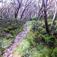
a tree, the last I would see for 4.5 hours. It took me that long to
reach the top of Mt Shillinglaw (1305m) 5 kilometers later. I didn't
get lost, but it was impossible to follow what faint trail there was
through the incredibly dense vegetation.
Basically, for hours on
end, I was just muscling through the jungle, clambering over fallen
trees, many of them burnt and black, and forcing my way through. So
long as I was heading up, I knew I was on track, but I did use my
GPS for occasional reassurance. Eventually I picked up a faint and
overgrown firetrail and followed it to the summit of Mt Shillinglaw,
more than two hours later than planned.
Anyone who has hiked this
section will understand what a relief it is to have that bit of
trail behind me. I reached the Jamieson-Licola road about 1:30pm and
found my food dump intact and enjoyed some treats for lunch. I've
had to revise back my goal for today and will remain about half a
day behind schedule.
I set off after lunch and a repack with my
fresh supplies that took 1.5 hours, but was a much needed break
after the travails of the morning. I now had a couple of kms on the
J-L road, then I decided to take Middle Ridge Road, a guide book
alternative, rather than the official AAWT route which climbed
higher for some views. I had seen the views when I put out my food
dump, and I had to gather some water before camping, including
enough to see me through tomorrow, and the only convenient stream
was the way I was going. I enjoyed a peaceful afternoon following
the road which contoured the mountain and gave great views to the
east until fog began to close in around 5pm.
The only downside to
the afternoon was my increased pack weight because I was now
carrying 5-6 days of food, made even worse when I added 5 liters of
water to the load 3km before I camped in a quiet little saddle about
1.5km past Rumpff Saddle soon after 6:30pm. In the fog and a breeze
it got cold very quickly and, after a flannel wash, I was wearing
most of my clothes while I cooked and ate. The fog is making
everything damp and the trees are dropping water on my tent, but I'm
cozy and hoping tomorrow will be at least a little easier than
today. I'm now following the Great Divide, and water is scarce for a
while.
|