|
Day: |
057 |
|
Date: |
Friday, 20 May 2016 |
|
Start: |
Newport |
|
Finish: |
Bangor Erris |
|
Daily
Kilometres: |
40 |
|
Total
Kilometres: |
1564 |
|
Weather: |
Overcast with occasional drizzle in the
morning and rain of varying intensity all afternoon |
|
Accommodation: |
Hillcrest House B&B |
|
Nutrition: |
Breakfast: Full Irish Breakfast
Lunch: Muesli bars and chocolate
Dinner: Baked salmon
& vegetables, apple tart & cream |
|
Aches: |
Sore feet |
|
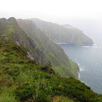
Highlight: |
Passing through the remotest Irish
countryside yet - a series of uninhabited valleys flanked by
treeless mountains and separated by mountain passes. Despite
the constant rain and endless bogs, it was an awesome day. |
|
Lowlight: |
I could say, missing a turn on the Western
Way and ending up walking the Bangor Trail instead, which meant a
much longer day and more distance, but it was a mistake worth
making. |
|
Pictures: |
Here |
|
GPS Track: |
Here |
|
Journal: |
I left the B&B at 9:00am, and after walking
along a main road out of town, turned to follow the Western Way on a
minor road that gradually became less used as it climbed away from
the coast following the side of a ridge. To the left were good
views across Lough Feeagh though intermittent drizzle and fog
interfered sometimes.
There followed some virtually
cross-country walking on an old grassy farm road before it descended
through some pretty groves of rhododendron to Derrybrook.
After a kilometre or two of road-walking the Western Way left to
follow a forest road and soon ended up at a forest car park.
It was raining and the signage was confusing. I couldn't find
a sign for the Western Way, but could find some ambiguous signage
for the Bangor Trail (not marked on my map), which I knew the
Western Way followed to some point. I decided to follow the
Bangor Trail markings for the time being. I knew it would
eventually end up at Bangor Erris, which was where I had a B&B
booked, but I had been planning to get there by bus from
Bellacorrick where the Western Way crossed a main road. I was
sure the Bangor Trail would be a longer hike, but thought that it
was doable if my navigation turned out to be in error.
After
some steady climbing on a rocky and very wet trail for a few
kilometres, there was a trail intersection, but no mention of the
Western Way. I thought the junction I was looking for might be
further on, but it never came. In retrospect, I must have
missed a marker back at the car park.
So the rest of the day
was spent following the Bangor Trail across wild (for Ireland)
country along a trail that became rougher, wetter and boggier the
further I went. The rain was almost continual, but often light
so the views were still impressive. The Trail wound its way
from valley to valley via low mountain passes with no signs of human
habitation, though there were sheep. Around 3:30pm, I came
across a sheep dragging itself off the trail with apparently a
broken back or broken rear legs. I thought I could find a
large rock and try to put it out of its misery, or leave it in the
hope that whoever owned it would find it in the next few days (it
could still eat and drink). Perhaps selfishly, as I later
reflected, I left it to its fate. It was raining and I had a
long way to go, and maybe that influenced my decision.
Soon
after, around 3:30pm, I reached a vandalised shelter that had a
Bangor Trail map in it, confirming my navigation error and
indicating that I had many kilometres to go. My best guess
from the map was that I still had five hours of walking, but that
was a big guess. I had my second and last break for the day in
the shelter (most of its roof had gone so it was pretty useless in
the weather) and pressed on, hoping that when I got to the top of
the next pass I would have phone reception so that I could call the
B&B, which was providing me with dinner. I did that, but had
to leave a voice-mail and hoped Evelyn, the proprietor, received it.
The rough track was extremely hard work. I had to keep
trying to work out what was less boggy, and occasionally nearly had
a boot sucked off. It's incredible how much water the
vegetation holds, especially in constant rain, and for a lot of the
time it was like walking on a sodden sponge. In other places
where the path was rocky, it was a raging stream or a deep puddle
because of the rain, and I just splashed along in an inch or two or
three of water, rather than wear myself out trying to dodge the
water.
I had no maps for this section, and tried to remember
the topology from the map back in the shelter to work out my
progress. I knew that a river crossing was coming near the
end, and when I got there found no bridge and the river wide.
After a few minutes trying to find a spot shallow enough to wade
through without getting water in my boots, I gave up. Plan B
was to put on my gaiters, for the first time in the trip, which
might allow me to get through deeper water without getting water in
my boots, provided I was quick. And that's what happened, I
splashed across as fast as I could and didn't feel my feet get
soaked, though they already felt a bit damp.
From there it
was another mountain pass and more extremely rough, boggy and wet
trail before I got the sense it was leaving the mountains. I
called Evelyn again about 7:15pm and said I would be there in
roughly an hour (guessing) and she insisted that she would still
provide dinner. It actually took ninety minutes to finally get
to Bangor Erris and Evelyn then insisted on taking my wet outer gear
to dry and after a shower gave me an excellent salmon dinner.
There are two other hikers here travelling in the opposite direction
who also got very wet today. I had a brief chat with them
while eating.
Because I'm further west than intended, I now
have further to go tomorrow to get to my next booked B&B (there's
nothing in between). I think tomorrow is going to be a long
and hard day on tired legs and feet. |
|
ADVENTURE LIST
Round Ireland
(2016)
Hume & Hovell Walking Track
(2013)
Via Alpina
(2012)
Australian Alps Walking
Track
(2011)
Land's End to John O'Groats
(2010)
Round Oz Bike Record Attempt
(2009)
Round Oz Bike Record Attempt
(2008)
Round Oz Bike Record Attempt
(2007)
Australia Tip to Top MTB
(2006)
Adelaide to Darwin MTB
(2005)
Sydney to Melbourne MTB
(2004)
Three Peaks Race
(2004)
Appalachian Trail
(1986)
Alpine Track
(1983)
|