|
Day: |
17 |
|
Date: |
Sunday, 10 April 2016 |
|
Start: |
Gougane Barra |
|
Finish: |
Glengarriff |
|
Daily
Kilometres: |
28 |
|
Total
Kilometres: |
525 |
|
Weather: |
Cold with strong winds and continuous
precipitation that changed from snow to sleet to rain as the day
wore on. |
|
Accommodation: |
The Perrin Inn |
|
Nutrition: |
Breakfast: Cereal, scambled eggs and
smoked salmon, scones and jam
Lunch: Jam tarts and
chocolate
Dinner: Burger with salad and chips, and apple
pie and ice-cream |
|
Aches: |
None really |
|
Highlight: |
Finding a hiker's picnic shelter (haven't
seen one for nearly two weeks) by the trail just when I was about to
give up on the idea of finding somewhere dry and protetcted for my
lunch snack. |
|
Lowlight: |
The last hour or two of hiking in steady
rain and being knocked all over the road by a strong crosswind when
I was tired, cold, hungry and damp. |
|
Pictures: |
Here |
|
GPS Track: |
Here |
|
Journal: |
I was woken several times during the night
by the wind buffetting the hotel, and in the morning snow was
falling steadily while I had my breakfast. I had checked the
forecast and it was for strong winds (gusting to 85kph) all day with
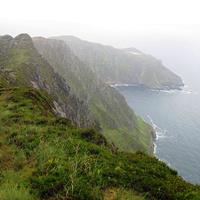
snow in the morning gradually turning to sleet then rain. My
route, now on the Beara Way, was going to climb to 600m as it
crossed a low mountain range, before gradually descending to the
sea. The wind was to be easterly, which meant it would be from
the side or behind for most of my day's travel, and that gave me
some confidence that conditions would be manageable.
The
hotel owner, Neil, was not keen for me to hike the route and
suggested delaying until later in the day, but the forecast didn't
really indicate any abatement in conditions and I wanted to give
myself plenty of time. So, after repacking my gear to make
additional clothing readily accessible, I set off at 9:30am in light
snow which was now settling on the ground.
The slog up and
over the mountain was slow, especially after the route left a farm
trail and became a cross-country trek. The snow cover made it
impossible to follow whatever trail there was, and instead, I
focused on looking for the next trail-marking post and aimed for
that. Visibility was limited to about 100m at times, but the
posts were frequent. It was extremely wet underfoot with
a sort of white/grey slush hiding muddy bogs. I fell over
numerous times, though always with a soft landing, and on a number
of occasions nearly had a boot sucked off in the morass as a foot
sank ever deeper into a gluey bog hidden by white snow. It was
very hard to judge what was solid and I generally tried to stick to
treading on the low brush and rocks where I could see them.
Over the crest of the mountain, the trail turned to the south and
the wind was viciously strong and cold from the side. I kept
telling myself that everything was OK, I wasn't hypothermic, and
that if I just kept moving forward, taking care not to make any
navigational errors, I would soon be descending.
Finally, I
did begin descending, though missed one turn and had to head
straight down the mountainside until I picked up another marker at a
much lower elevation. I reached a farm and then a country
lane. It had taken me three hours to go seven kilometres. I
began looking despairingly for somewhere to get shelter and have a
snack when suddenly there appeared a hikers' picnic shelter, the
first I had seen in many days. I stopped to have a snack and
drink, though before long I was shivering and knew I had better get
moving again.
The remainder of the day was mostly walking on
very quiet rural roads apart from one section of very boggy forest
trail. It rained steadily and in places was very wind-exposed.
There was nowhere to stop, so I just kept walking, apart from a
brief detour to look at some Bronze Age standing stones. It
took longer than I expected to reach my target of Glengarriff, and
one section of road in particular lingers in my memory. It was
on a barren high plain, totally exposed to the wind and rain, and it
just seemed to go on forever (about 3km, in fact). I found it
difficult to walk in a straight line as the wind knocked me around
and I could think of many places I would rather have been.
However, this is part of hiking and I can remember other days, just
as bad, in other parts of the world.
I knew that if I just
kept moving along I would eventually get to my accommodation, be
able to dry out and get some food, and at 5:30pm that's what
happened when I arrived at the Perrin Inn in Glengarriff, a seaside
village. The two old guys in the bar were very entertained by
my dripping arrival, though I couldn't understand most of what they
said. I did catch the bit about the severe weather warning
being in effect until 6:00am tomorrow. The friendly
manageress, gave me a key to my very basic room and I set about
spreading out my stuff to dry before a hot shower.
Later,
after booking accommodation for the next two nights, I returned to
the bar and learned the local shop closes early on Sunday, but was
happy enough ordering from the resonably-priced bar menu for dinner
and including a dessert since there would be no snacks tonight.
Breakfast isn't served until 9:00am, so it looks like I will be
sleeping in. The weather forecast for tomorrow, though better
than today, isn't that good, but I don't have too far to go. |
|
ADVENTURE LIST
Round Ireland
(2016)
Hume & Hovell Walking Track
(2013)
Via Alpina
(2012)
Australian Alps Walking
Track
(2011)
Land's End to John O'Groats
(2010)
Round Oz Bike Record Attempt
(2009)
Round Oz Bike Record Attempt
(2008)
Round Oz Bike Record Attempt
(2007)
Australia Tip to Top MTB
(2006)
Adelaide to Darwin MTB
(2005)
Sydney to Melbourne MTB
(2004)
Three Peaks Race
(2004)
Appalachian Trail
(1986)
Alpine Track
(1983)
|