|
Day: |
017 |
|
Date: |
Thursday, 31 March 2011
|
|
Start: |
Johnnies Track & Beloka Range Track Junction
|
|
Finish: |
Buckwong Creek plus 1km
|
|
Camp Location |
Here |
|
Daily
Kilometres: |
26.2
|
|
Total
Kilometres: |
370.3 AAWT
|
|
Animal Encounters |
Birds, brumbies
|
|
People Encounters |
Two 4WDs, two logging trucks
|
|
Weather: |
Cold foggy and overcast in the morning, sunny and mild in the
afternoon
|
|
Pictures: |
Here |
|
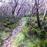
Journal: |
I woke at 7 AM to a fairly thick fog and still air. Everything
was very damp and it was cold. Still that way when I started walking
at 9 AM along Johnnies Top Track. After a couple of kilometres on
the fire trail I reached Johnnies Top (1556m) and then began
following a faint trail down a long spur. The trail was easy enough
to follow and I enjoyed walking through the snowgum forest on the
gentle downgrade in the fog. After a few hours the fog cleared and
after a final steep descent I reached the end of the spur and Buenba
Creek. I was supposed to follow it upstream but first had to cross
Corner Creek, which turned out to be very marshy with several
channels. My feet got wet again. Curses!
Eventually I reached drier ground and then followed brumby trails
parallel with the creek along the treed grassy flats. There were
lots of horse droppings but no brumbies. There were also lots of
boggy bits. Pleasant walking, nevertheless. Eventually I reached the
Buenba Hut site on a grassy plain. The only evidence of the hut was
a couple of poplar trees. It had been farmed once and there were
traces of fences and gates. I had lunch under the poplars and spread
out my tent, sleeping bag, etc., to dry in the pleasant sunshine.
After lunch the trail, again faint, climbed gradually through
scrubby country to eventually reach Mt Hope Road, where two logging
trucks were parked with the drivers having a yarn. They chatted with
me for a while and offered me water and to charge my phone. Nice
guys. By now it was after 4 PM and the balance of the day was easy
walking down a fire trial as far as Buckwong Creek. From there I
followed the creek upstream for a kilometre until I found a campsite
by a small tributary after seeing some brumbies along the way. It
was all a little damp and grassy and will be wet in the morning. I
could hear dingoes or feral dogs howling as I went to bed at 8:30
PM.
|
|
ADVENTURE LIST
Round Ireland
(2016)
Hume & Hovell Walking Track
(2013)
Via Alpina
(2012)
Australian Alps Walking
Track
(2011)
Land's End to John O'Groats
(2010)
Round Oz Bike Record Attempt
(2009)
Round Oz Bike Record Attempt
(2008)
Round Oz Bike Record Attempt
(2007)
Australia Tip to Top MTB
(2006)
Adelaide to Darwin MTB
(2005)
Sydney to Melbourne MTB
(2004)
Three Peaks Race
(2004)
Appalachian Trail
(1986)
Alpine Track
(1983)
|